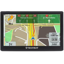
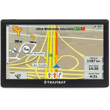
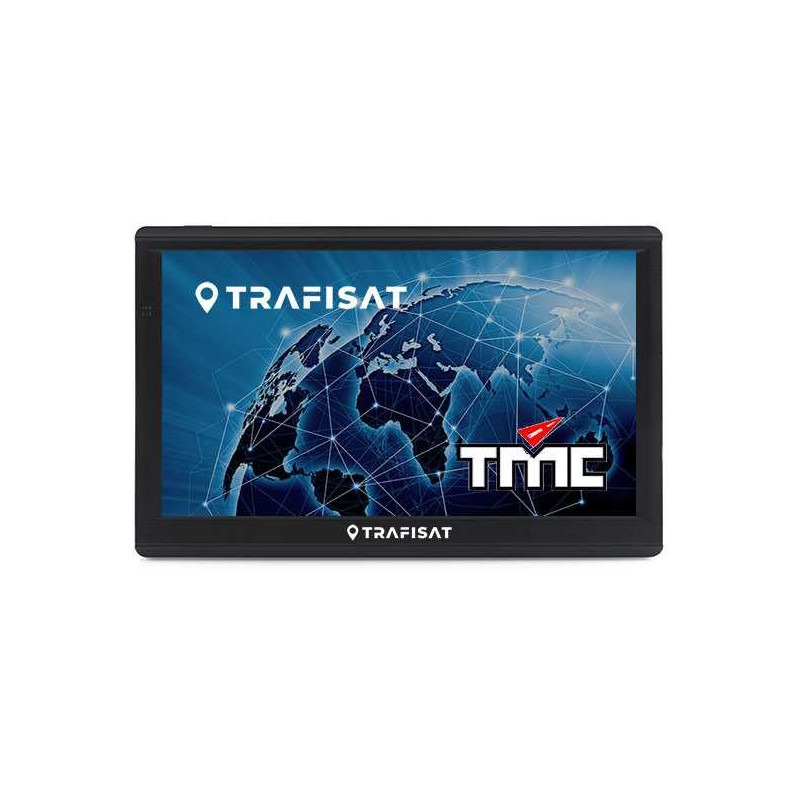
Navigator for campers, minibuses and cars with professional software and two European maps, calculating routes based on entered parameters. High-contrast touch-sensitive LCD screen is controlled by touch. Clear voice commands, advanced graphics and controls have long made this type of navigator the most popular among professional and amateur drivers.
SPECIFICATION
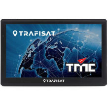
• Brand Trafisat
• Model N7277 Car
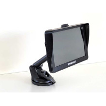
• Screen 7" Capasitive IPS LCD (sensory non-calibrating)
• High contrast screen - Yes
• Screen sun protection - Yes (integrated into the housing)
• Housing - Sturdy finely ribbed (unpainted)
• GPS receiver - Sensitive 66 channels
• Processor Media Tek MT2531 800MHz
• RAM DDR3 512MB
• Internal working memory 16GB
• Memory card slot - Yes (microSD up to 128GB)
• FM transmitter - Yes
• USB connectivity - Yes (USB-C)
• Audio output: Internal speaker and 3.5 mm headphone jack
• Battery technology Li-Ion (2500 mAh)
• Operating system Win CE 6.0
• Navigation program - Yes (LT, RU, PL, EN, etc. languages)
• European maps - Yes (two manufacturers)
PACKAGE COMPONENTS
• 7" navigator with usb-c, new generation touch screen
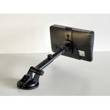
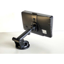
• Extendable holder leg with adhesive suction cup
• Nozzle, firmly attached to the body
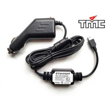
• 12/24V charger with 1.5m usb-c cable
• usb-c cable
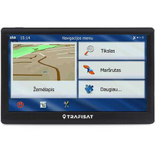
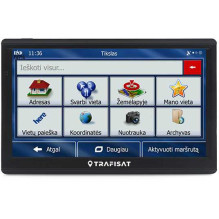
NAVIGATION FEATURES
• Very convenient and simple menu (familiar program, modified by euronet.lt)
• Destination entry: 1. Address 2. Point on the map 3. Postal code 4. Coordinates 5. Archive 6. Your location.
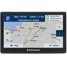
• Navigation: after entering the address, it takes into account the type of car, calculates and shows the entire route, time and distance on the map. While driving, it pulls up the map, speaks and shows how to drive. If you make a wrong turn, it recalculates the route. When approaching an unexpected obstacle, it allows you to avoid it, etc.
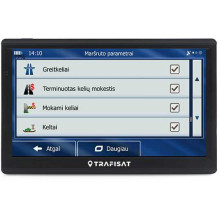
• Trip planning: simple, with intermediate points
• Calculation method: fast, short, economical, easy
• Minibus or camper navigation, by selecting the height and width of the car
• Boat navigation, by selecting the "Straight" calculation
• Smart Routes - the fastest routes depending on the time of day and week
• Saving your places on the map for later navigation
• Saving created routes for later navigation
• Detour (manual): bypassing a road, section, border crossing, country, etc.
• Navigation menu: Lithuanian (euronet.lt), Russian (euronet.lt), Polish, English, etc.
• Navigation voices: Lithuanian (modified euronet.lt), Russian, Polish, English, etc.
• Route planning (A-B) allows you to check and save the route from the entered location to the destination.
• Route planning (A-B-C) allows you to save routes with many intermediate points and detours for the future.
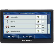
VEHICLE SELECTION
• Minibus: the navigation program starts, evaluating the dimensions.
• Car / Taxi / Bicycle / Pedestrian / Boat (Navigation "Direct")
GRAPHICS
• 3D / 2D scrolling navigation map graphics / 3D buildings and landmarks
• 3D / 2D realistic terrain (ravines, mountains, vegetation, water bodies, etc.)
• Lane Guidance / Real Signpost - assistance at multi-lane intersections / realistic signposts
• Color modes: the program switches to night / day color mode automatically
INFORMATION
The program displays your selected POI (speed cameras, gas stations, truck parking lots, etc.)
MAP SELECTION
The navigator has two European maps from different providers. You can use any one.
SERVICE IN LITHUANIAN, RUSSIAN AND ENGLISH
• By purchasing a navigator, you get professional service in three languages
• A company that purchases these navigators can rest assured that it has received a product with service.
ОПИСАНИЕНавигатор для легкового транспорта с профессиональной программой и двумя картами Европы, подсчитывающий маршруты по введенным параметрам веса, высоты, ADR и др. Высококонтрастный сенсорный LCD екран управляется легкими прикосновениями. Ясные голосовые подсказки на русском, графика и несложное управление сделали навигаторы такого типа самыми популярными среди профи.
СПЕЦИФИКАЦИЯ• Производственное имя - Trafisat
• Модель - N7277 Car
• Екран - 7" Capasitive IPS LCD (сенсорный, свободный от раскалибровки)
• Екран повышенной контрастности - Да
• Защита от солнца - Heт
• Корпус - Крепкий мелко зернистый (некрашенный)
• GPS приемник - Чувствительный 66 канала
• Процессор - Media Tek MT2531 800MHz
• Операционная память - DDR3 512MB
• Рабочая внутренняя память - 16GB
• Гнездо внешней памяти - Да (microSD до 128 GB)
• FM передатчик - Да
• USB подключение - Да (USB-C)
• Звук - Внутренний громкоговоритель и 3,5 mm гнездо
• Аккумулятор - Li-Ion (2500 mAh)
• OС - Win CE 6.0
• Программа навигации - Да (LT, RU, PL, EN и дрю языки)
• Европейские карты - Да (двух производителей)
СОСТАВ КОМПЛЕКТА• 7" навигатор с сенсорным экраном LCD IPS
• Ножка держателя, удлиняемая, врощаемая 360º/45º, держатель
• 12/24V зарядное устройство
• Провод для зарядки и данных USB-C
СВОЙСТВА НАВИГАЦИИ• Оченр удобный и простой меню управления (небезизвестная програмаб модифицированная euronet.lt)
• Ввод целли: 1.Адрес 2.Точка в карте 3.Почтовый код 4.Координаты 5.Архив 6.Сохраненная точка
• Навигация: после выбора цели подсчитывает и на карте показывает весь маршрут, время и расстояние. При езде увеличивает карту, говорит и показывает, как ехать. Повернув не правильно быстро пересчитывает маршрут. Тд.
• Планировка: обычная, с промежуточными точками
• Методы подсчета маршрутов: быстрый, короткий, экономнвй, легкий
• Навигация микроавтобусов и кемперов при выборе высоты и ширины автомобиля
• Smart Routes - маршруты, зависящие от времени суток и дня недели
• Сохранение в памяти ваших мест и вами созданных маршрутов для последующей навигации
• Объезд (ручной): дороги, промежутка, пункта пересечения границы, др.
• Меню и голос навигации: русский, англисский, немецкий, литовский, др.
• Пданировка маршрута (A-B) позволяет проверить и сохранить маршрут от места до цели
• Пданировка маршрута (A-B-C) позволяет проверить и сохранить маршруты со многими целями и объездами
ВЫБОР ТРАНСПОРТНОГО СРЕДСТВА• Легковой, такси, двухколесный, пешеход, любитедьское судно (навигация "прямо")
ГРАФИКА• 3D / 2D графика карты навигации, здания и орентиры
• 3D / 2D правдоподобный рельеф (горы, воды, растения, поселкиб тп.)
• Lane Guidance / Real Signpost - помощ во многополосовых перекрестках / Правдоподобные дорожные знаки
• Цветовые режимы: ночной или дневной цвет (автопереключение)
ИНФОРМАТОРПрограмма показывает ваши места POI (газозаправки, паркинги для грузовиков, камеры скорости, тп.)
КАРТЫВозможность использовать две карты Европейских стран (внутри)
ОБСЛУЖИВАНИЕ НА РУССКОМ• Преобретив навигатор, приобретаете и обслуживание на русском языке
• Предприятие может быть спокойна, что преобрела вещь с обслугой. Водителя не останутся без помощи и советов