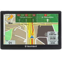
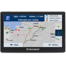
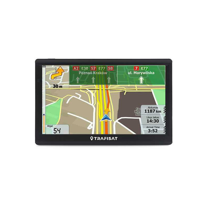
Truck, bus and car navigator with professional software and two European maps, calculating routes based on entered parameters of weight, height, ADR, etc. High-contrast touch-sensitive LCD screen is controlled by touch. Clear voice commands, advanced graphics and controls have long made this type of navigator the most popular among professional and amateur drivers.
SPECIFICATION
• Brand Trafisat
• Model N721S 256/16 Truck
• Screen 7" Capasitive IPS LCD (sensory non-calibrating)
• High contrast screen - Yes
• Screen sun protection - Yes (integrated into the housing)
• Housing - Rugged finely ribbed (unpainted)
• GPS receiver - Sensitive 66 channels
• Processor Media Tek MT2531 800MHz
• RAM DDR3 256MB
• Internal working memory 16GB
• Memory card slot - Yes (microSD up to 128GB)
• FM transmitter - Yes
• FM RDS TMC receiver - No
• USB connectivity - Yes (USB-C)
• Audio output: Internal speaker and 3.5 mm headphone jack
• Battery technology Li-Ion (2500 mAh)
• Operating system Win CE 6.0
• Navigation program - Yes (LT, RU, PL, EN, etc. languages)
• European maps - Yes (two manufacturers)
PACKAGE COMPOSITION
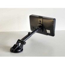
• 7" navigator with usb-c, new generation touch screen and integrated sun canopy
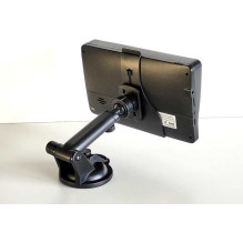
• Extendable holder leg with adhesive suction cup
• Nozzle, firmly attached to the body
• 12/24V charger with 1.5m usb-c cable
• usb-c cable
NAVIGATION FEATURES
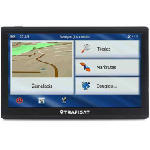
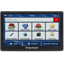
• Very convenient and simple menu (familiar program, modified by euronet.lt)
• Destination entry: 1. Address 2. Point on the map 3. Postal code 4. Coordinates 5. Archive 6. Your location.
• Navigation: after entering the address, it takes into account the type of car, calculates and displays the entire route, time and distance on the map. While driving, it draws a map, speaks and shows you how to drive. If you make a wrong turn, it recalculates the route. When approaching an unexpected obstacle, it allows you to avoid it, etc.
• Trip planning: simple, with intermediate points
• Calculation method: fast, short, economical, easy
• Truck navigation through prohibited signs to loading in settlements
• Display of industrial zones
• Minibus or camper navigation, by selecting the height and width of the car
• Boat navigation, by selecting the "Straight" calculation
• Smart Routes - the fastest routes depending on the time of day and week
• Saving your places on the map for later navigation
• Saving created routes for later navigation
• Detour (manual): by road, section, border crossing, country, etc. detour
• Navigation menu: Lithuanian (euronet.lt), Russian (euronet.lt), Polish, English, etc.
• Navigation voices: Lithuanian (modified euronet.lt), Russian, Polish, English, etc.
• Route planning (A-B) allows you to check and save the route from the entered location to the destination.
• Route planning (A-B-C) allows you to save routes with many intermediate points and detours for the future.
VEHICLE SELECTION
• Truck: starts a professional truck navigation program that evaluates the dimensions (weight, axle weight, length, height, width) and the ADR of the cargo.
• Bus: starts a professional bus navigation program that evaluates the dimensions of the bus.
• Car / Taxi / Bicycle / Pedestrian / Boat (Navigation "Direct")
GRAPHICS
• 3D / 2D scrolling navigation map graphics / 3D buildings and landmarks
• 3D / 2D realistic terrain (ravines, mountains, vegetation, water bodies, etc.)
• Lane Guidance / Real Signpost - assistance at multi-lane intersections / realistic signposts
• Color modes: the program switches to night / day color mode automatically
INFORMATION
The program displays your selected POI (speed cameras, gas stations, truck parking lots, etc.)
MAP SELECTION
The navigator has two European maps from different providers. You can use any one.
SERVICE IN LITHUANIAN, RUSSIAN AND ENGLISH
• When you purchase a navigator, you get professional service in three languages
• A company that purchases these navigators can rest assured that they have received a product with service. Drivers (and foreigners) will not be left without help, advice, and service.
ОПИСАНИЕНавигатор для грузового и легкового транспорта с профессиональной программой и двумя картами Европы, подсчитывающий маршруты по введенным параметрам веса, высоты, ADR и др. Высококонтрастный сенсорный LCD екран управляется легкими прикосновениями. Ясные голосовые подсказки на русском, графика и несложное управление сделали навигаторы такого типа самыми популярными среди профи.
СПЕЦИФИКАЦИЯ• Производственное имя - Trafisat• Модель - N721S 256/16 Truck